Sharon Hawley

Saturday, February 14, 2015
Tuesday, October 21, 2014
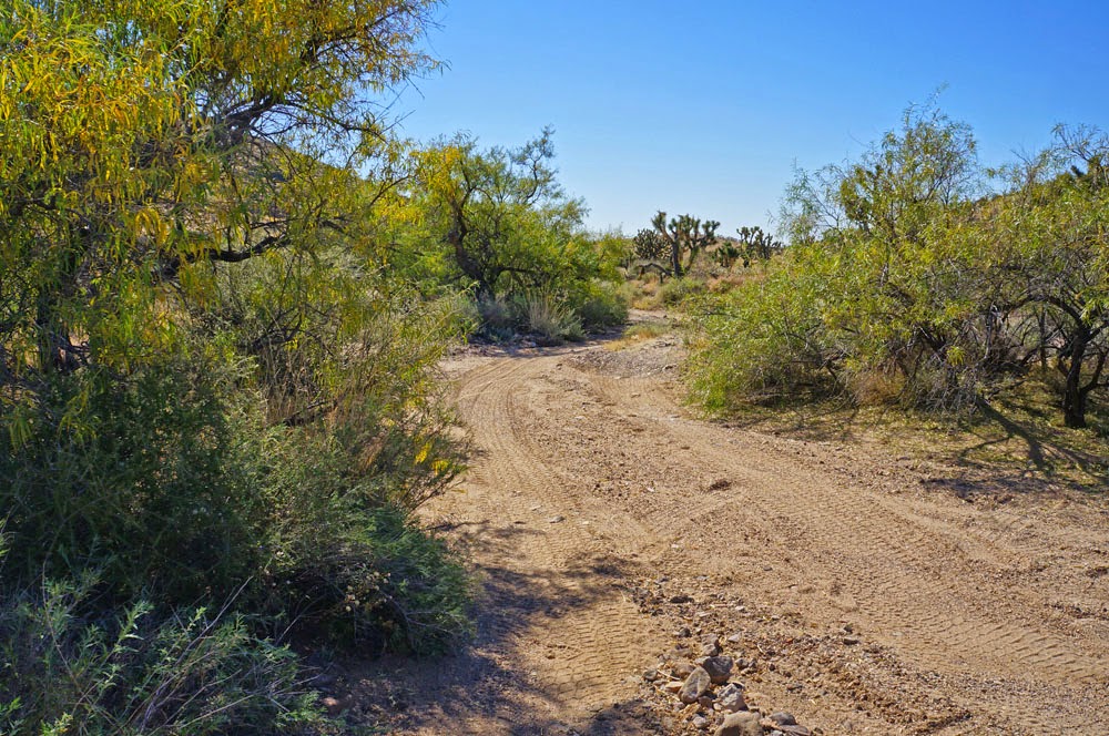
Castle Peaks
How much time, money and effort are justified in reaching a
goal? It depends on the goal, you
say.
Suppose you’re nearing the end of a month-long stay on the
Mojave Desert and all of the hot spots (the really important rocks and cacti
you wanted to see) have been visited, photographed, and mostly posted on your
website.
So it was that I might have spent a bit more resources getting
to Castle Peaks than it was worth. But
that’s a judgment call. It depends on
how enjoyable a destination is and how much I enjoy the journey. It also depends on how much I might learn,
and on more subtle aspects of being alone doing something that is difficult and
undone by almost everyone. After reading
on, I ask your opinions.


 |
| Granite of mostly quattz and feldspar |
 |
| andesite - volcanic rock |
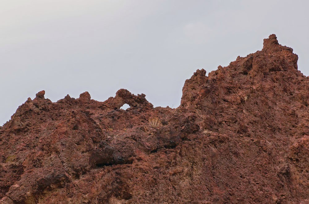
The rocks up here are igneous, either intrusions of granite, in which prospectors have searched for gold, or andesites
of lavas and volcanoes.


Sunday, October 19, 2014
Small Towns of Southern Nevada
After each of several hikes in the Mojave National Preserve
and nearby wildernesses, I’ve stopped in most of the towns of southern Nevada,
and across the line in California. These
are few and small, except of course for Las Vegas. Here is what I’ve learned, and it won’t take
long.


Nipton, California, is a store and a hotel. It’s on a paved road east of I-15 by the railroad. You can stay here for $78, but if you require bedding or towels , that’s $7 more; and there is no internet. The train comes rumbling through several times during the night, but they offer ear plugs on request.


Goodsprings, Nevada, on Highway 161 west of Jean, is a saloon and a store. I stopped here for a beer. It’s a fine old-west saloon with a small museum and a lot of history from the mining time before Las Vegas existed.
Searchligjt, Nevada, is on Highway 95 south of Henderson. It has a fine country café and casino, a good
stop for a meal. Sorry, I have no
picture.
 |
| Bun Boy is gone, sorry to say |

Baker, California, on I-15 south of Las Vegas, used to be a fine place to stop at Bun Boy and enjoy a good breakfast and observe the world’s largest thermometer. The thermometer is still there and appears to keep good temperature, but Bun Boy and the motel are closed. All that remains is Mad Greek Café and a new Denny’s Restaurant. Gas is much too expensive here; wait til you get to Las Vegas if you can.
Primm, Nevada, is a casino town just north of the Nevada state
line. It offers rooms without internet
and a buffet that is not bad.

 That leaves, not a town, but an enclave of solar expectation,
costing more and expecting more that all the above mentioned towns put
together. I saw it best while driving
west from Nipton—Ivanpah Solar plant south of Primm. It opened on February 13, 2014 with a planned
gross capacity of 392 megawatts of solat power. That’s equal to the combined output of three
of the 17 turbines at Boulder Dam. The
plant uses 173,500 heliostats, mirrors
that focus the sun’s rays on boilers high three towers. It is the world's
largest solar power station.
That leaves, not a town, but an enclave of solar expectation,
costing more and expecting more that all the above mentioned towns put
together. I saw it best while driving
west from Nipton—Ivanpah Solar plant south of Primm. It opened on February 13, 2014 with a planned
gross capacity of 392 megawatts of solat power. That’s equal to the combined output of three
of the 17 turbines at Boulder Dam. The
plant uses 173,500 heliostats, mirrors
that focus the sun’s rays on boilers high three towers. It is the world's
largest solar power station.Saturday, October 18, 2014
Arizona Hot Springs

Sometime after the morning of creation, some adventurous white rocks rumbled down from newly risen Wilson Ridge. You remember the Ridge from my mentioning it on October 4, because you pay close attention to all passing comments in all the blogs and posts you read. I remembered my distant view of Wilson Ridge after reading that the strange white rocks I saw today came from there. They traveled some thirty miles and probably did it rather quickly, tumbling down a desert gorge. They made a few lazy turns with each 100-year storm, and maybe traveled a mile in each 1,000-year gully-washer. Isn’t it great to be jolted into remembrance from so long ago by something that happens today? But first, an introduction.

Calling it a trailhead implies there is a trail. But I soon learned that it’s just the way a
few people and wild burros have traveled.
I headed down White Rock Wash which would join the Colorado River. This is low elevation desert below Boulder Dam,
so vegetation is sparse and in the summer it can get very hot. Today, in the low nineties and partly shaded
within the canyon, it was pleasant.


And there I saw them—the bright white rocks, so out-of-place with dark volcanic rock all around. Strangers in a foreign land, they are no longer sharply broken as when they fell from Wilson ridge so long ago, but rounded from miles of tumbling and thumping with the push and splash of turbulent water.


And I saw conglomerate rocks in the making, along the banks of White Rock Wash. The cementing material, still soft enough to chip away with my walking stick, but in just a few thousand years, this might be another terrazzo floor. Notice the little piece of desert above the conglomerate, the way a desert often looks when we don’t see underneith it.


I walked a rocky “use trail” downstream along its bank, looking for another gulch that should enter the river on my side. (A use trail is just where people and animals have traveled. It often splits, leaving a quandary as to which way to go.) I scrambled along the steep banks of the Colorado looking for an entering watercourse which should be Hot Spring Canyon.

I came to a gulch with a small flow of water entering the Colorado. On testing its temperature with my hand, I knew it flowed from a hot spring.


Turning into the canyon, I climbed up a few little waterfalls, as the water kept getting hotter. In the narrow windless canyon, it was like walking in a sauna.

And then a deep clear pool of hot water, reminder of the earth’s hot interior that formed the pyroclastic flow. A world still hot and waiting for the signal to strike again.

From here I had two choices for getting back to the car. I could go back the way I came. Or I could use the map, which indicated a fair overland route continuing up Hot Spring Canyon, then over a ridge and back into White Rock Wash near the trailhead. I always hesitate going back via an unproven route, but this one seemed doable, and I had enough daylight to retreat if necessary. I suppose if some major problem has arisen, I would have told you. Who knows?
 |
| Keith Brantley |

I returned in time to shower before driving to Keith Brantley’s monthly Poet’s Corner at West Las Vegas Arts Center to read a few things about wilderness walks and to ask if anyone knows where Mt. Charleston is. One person did, but she had not been there.
You can enlarge any picture.
Just click on it. Then click the “back”
button to return to where you were.
Wednesday, October 15, 2014
Another try for Piute Gorge


 A book describing places to visit in the Mojave National
Preserve describes Piute Gorge as having the “only year-round stream in the
East Mojave Desert,” and “a spectacular mile-long gorge for the geologist.” The book advises that it is not easy to get
to the trailhead for Piute Gorge, “a four-wheel-drive vehicle is necessary,”
and the rough road is ten miles long. It
further says that from the trailhead, there is a “use trail” which is often
hard to find, and some scrambling is required.
A website shows these pictures, from someone who made it into the gorge.
With that enticement, and time on my hands, how could I not make a second
attempt.
A book describing places to visit in the Mojave National
Preserve describes Piute Gorge as having the “only year-round stream in the
East Mojave Desert,” and “a spectacular mile-long gorge for the geologist.” The book advises that it is not easy to get
to the trailhead for Piute Gorge, “a four-wheel-drive vehicle is necessary,”
and the rough road is ten miles long. It
further says that from the trailhead, there is a “use trail” which is often
hard to find, and some scrambling is required.
A website shows these pictures, from someone who made it into the gorge.
With that enticement, and time on my hands, how could I not make a second
attempt. 

 I drove eight miles in
an hour-and-a-half and made it to within two miles of the trailhead. There, I looked at a steep rocky jeep trail proceeding
into the mountains. This is the way
roads were before they were graded, graveled and even paved. I had made it close to the trailhead and
could make it all the way, even if I had to walk. I had done it! These were my growing thoughts as I parked
the jeep in the hot sunbaked hills west of Highway 95.
I drove eight miles in
an hour-and-a-half and made it to within two miles of the trailhead. There, I looked at a steep rocky jeep trail proceeding
into the mountains. This is the way
roads were before they were graded, graveled and even paved. I had made it close to the trailhead and
could make it all the way, even if I had to walk. I had done it! These were my growing thoughts as I parked
the jeep in the hot sunbaked hills west of Highway 95.
I can’t say that driving a jeep on roads like this is
fun. Some people think it is, but for me
it’s just a necessity for wilderness experience. I decided that walking would be just as fast
and might avoid damaging my almost-new jeep.
And nice walk it was. I was
finally and thrillingly isolated from all humanity and fully on my own.


 The trail petered out after a mile, and I spent an hour
looking for it. Surely it would drop
into the gorge, so I scrambled down a little dry-wash into the Piute Gorge, hoping
to find the trail in the bottom. A small
trickle of water was flowing among the trees, just as the book said. But the underbrush was so thick I could not
proceed upstream. So I climbed back up
the side to look again for the trail.
The trail petered out after a mile, and I spent an hour
looking for it. Surely it would drop
into the gorge, so I scrambled down a little dry-wash into the Piute Gorge, hoping
to find the trail in the bottom. A small
trickle of water was flowing among the trees, just as the book said. But the underbrush was so thick I could not
proceed upstream. So I climbed back up
the side to look again for the trail. 
 I proceeded parallel to the gorge, along the mountainside, looking for a trail. Soon the slope became
too steep to continue. I climbed higher,
looking for a passable route, but found none. I sat down to think. My thinking seemed all grainy and sluggish
from hard walking and from having slipped on the loose rubble a few times. I was not injured, but considered the
consequences if I were. How frail the
human body is against all that is sharp and hard. If there was a trail into the gorge, I could
not find it. If I had hoped to prove my
independence, I had done just the opposite.
These pictures are from the end of my ability go further. I looked into Piute Gorge from far above, but
could not find a way in.
I proceeded parallel to the gorge, along the mountainside, looking for a trail. Soon the slope became
too steep to continue. I climbed higher,
looking for a passable route, but found none. I sat down to think. My thinking seemed all grainy and sluggish
from hard walking and from having slipped on the loose rubble a few times. I was not injured, but considered the
consequences if I were. How frail the
human body is against all that is sharp and hard. If there was a trail into the gorge, I could
not find it. If I had hoped to prove my
independence, I had done just the opposite.
These pictures are from the end of my ability go further. I looked into Piute Gorge from far above, but
could not find a way in.
Having made my way bumpily, into this remote place, I made it
bumpily back out. I drove back to
Searchlight and bought a breakfast of poached eggs and toast, a celebration of
being alive, and having tried.

Back at the motel, a sunset outlining peaks.
Subscribe to:
Posts (Atom)